Birding Adventures along the Bismarck-Mandan Birding Drive
A Journey of Discovery
Just as Lewis and Clark explored the Bismarck-Mandan region over 200 years ago, today explorers search for new experiences in the Missouri River Valley and the adjacent prairies, wetlands and woods. Now you can follow the paths of such renowned early explorers as Audubon, Baird and Sprague, by searching for the wealth of birds that can be found on the Bismarck-Mandan Birding Drive.
Along each of the three driving routes, you will be rewarded with a bounty of opportunities to observe, study and photograph interesting birds amid historic landscapes in the Northern Great Plains.
Just as early explorers documented their travels through the Bismarck-Mandan area, you too can explore the fertile landscape along scenic backroads that will provide memorable days afield. Visit areas where the quiet stillness is broken only by the mixed chorus of birds, where the native prairie is broken only by the horizon, and where remarkable wildlife and wild lands will bring you back time and time again. Each day yields new discoveries along the Bismarck-Mandan Birding Drive.
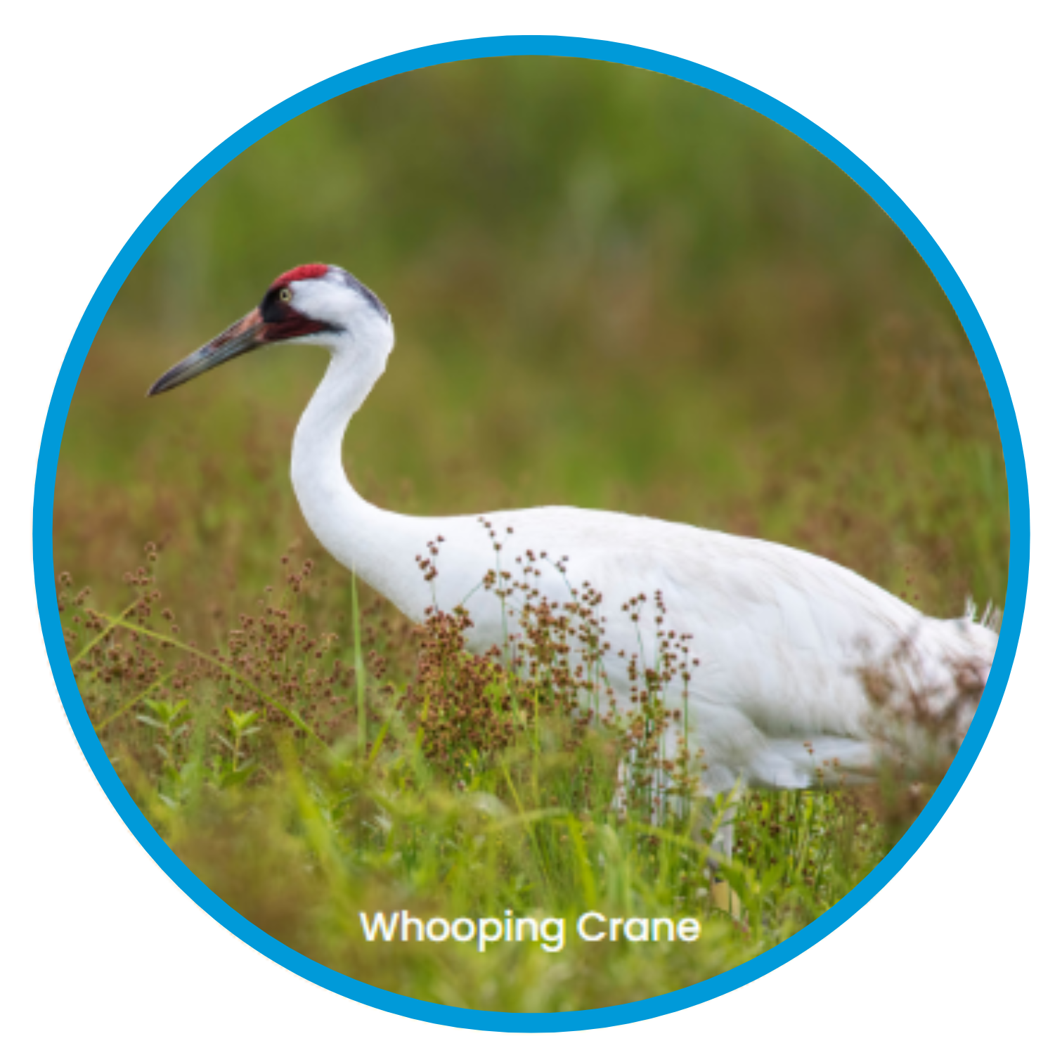
In this heartland of America, near the center of the continent, you will encounter national symbols – Bald Eagles and Wild Turkeys - as well as state symbols - Western Meadowlarks and Ring-necked Pheasants. You will find endangered species - Piping Plovers and Least Terns - and more common birds such as American White Pelicans and Swainson’s Hawks. Seasons progress at a quick pace in the Northern Plains, so if you drive along one of the birding routes every two weeks, you will surely notice differences in the birds you see. Spring breaks with the advance of flocks of thousands of geese and ducks. As migration progresses, you will find shorebirds on their way to Arctic nesting ranges (such as Hudsonian Godwits, White-rumped Sandpipers, and Stilt Sandpipers), followed by throngs of colorful songbirds including a variety of wood warblers on their way north from wintering ranges in Central and South America. You may even spy the rarest of all Dakota birds - Whooping Cranes.
You can find 15 species of ducks some days, and during summer, the wealth of ducks will astound you as new broods augment adult populations. Bobolinks, kingbirds and native sparrows claim the grasslands, and exciting birds of prey soar overhead. Even our winters offer exciting birding opportunities to see such dramatic birds as Snowy Owls, Rough-legged Hawks, Snow Buntings, Red-breasted Nuthatches and Red Crossbills.
Some of the exciting focus birds that attract out-of-state birders to this region include Ferruginous Hawks, Franklin’s Gulls, Black Terns, Upland Sandpipers, American Avocets, Wilson’s Phalaropes, Gray Partridge, Rock Wrens, Sprague’s Pipits, Baird’s Sparrows, LeConte’s Sparrows, Lark Sparrows, Black-headed Grosbeaks, Spotted Towhees and Lazuli Buntings.
In addition, some interesting birds that you are almost sure to encounter during most of the year include Wood Ducks, American Kestrels, Sharp-tailed Grouse, Wild Turkeys, Turkey Vultures, Black-billed Magpies, Eastern and Western Kingbirds and Yellow-headed Blackbirds. What more can you ask for? Come join us for a journey of discovery and enjoy a true Dakota experience along the Bismarck-Mandan Birding Drive!
A Journey of Birding
The Bismarck-Mandan Birding Drive is composed of three impressive routes that loop out from the urban center - the Missouri River Route, the McKenzie Route and the Little Heart Route. The Missouri River Route leads you north from Bismarck along the east side of the Missouri River floodplain and meanders along the buttes of the Missouri Breaks, where you will find an interesting variety of birds that inhabit the forested river bottoms and the neighboring prairie hills. Painted Woods Lake provides a look at wetland birds and provides a pleasant hiking route. Just north of the town of Washburn you can access the river woodlands at the Lewis and Clark Historic Site. From there, you cross the mighty Missouri and follow the west side of the valley, which is a bit more rugged and includes stops at two exceptional natural areas - the Cross Ranch State Park and Smith Grove, an ancient forest - before returning to the city of Mandan.
The McKenzie Route leads you east of Bismarck to a series of very productive wetlands that attract an exciting assortment of waterfowl, shorebirds and other species, including McKenzie Slough and Long Lake National Wildlife Refuge, which are both exceptional locations to photograph birds and other wildlife. The return route directs you back along the Missouri River Valley south of Bismarck, where you can access forested bottomlands, the riverbanks, and sandbars at McLean Bottoms and Kimball Bottoms.
Mandan is where the West begins, and it’s also where the Little Heart Route starts, leading you south of Mandan, past historic Fort Abraham Lincoln to the wild Oahe woods at the Little Heart Bottoms and Sugarloaf Bottoms. Just south of Sugarloaf you pass through a corridor of Badlands formations before scaling the wooded bluffs of the Huff Hills. A backroad drive leads west to Highway 6, which will return you to Mandan, perhaps with a stop at the Morton County Wildlife Area and one last stop at the Northern Great Plains Research Laboratory, just before you re-cross the Heart River to enter Mandan.
Missouri River Route
North of Bismarck-Mandan
This historic route follows the edge of the river valley where river, woods and prairie vistas attract an exciting variety of Dakota birds. Beginning your trip from Interstate 94, take Exit 157 and turn N 1 block, where you turn W (left), then right, to the Bismarck-Mandan Visitor Center at 1600 Burnt Boat Drive.
Exiting from the Visitor Center parking lot, turn W (right) on Burnt Boat Drive and continue ¾ mile to the “T” at its intersection with River Road. Turn N (right) to follow River Road about 4 miles to its intersection with Burnt Creek Loop. Turn E (right) onto Burnt Creek Loop, then immediately N (left) onto Highway 1804. Follow this for 5 miles to the Double Ditch Scenic Turnoff W (left), which is located about 1 mile N of Double Ditch State Historic Site. Return to Highway 1804 and drive N for 3-1/2 miles, where you can turn E on 175 Avenue for about 1 mile to explore the surrounding buttes and coulees from the road, then return to Hwy 1804.
Continue N on Highway 1804 for 16-1/2 miles, where you turn W about 1-1/2 miles to the Painted Woods Lake hiking trailhead. Return to Highway 1804, where you turn N 1-1/2 miles to Highway 83, where you turn NW (left) and proceed about 7 miles to the town of Washburn, where you turn left on Alternate Highway 200. After just 1/3 mile, turn right toward the Lewis and Clark Interpretive Center and continue about 3 miles to the Fort Mandan Historic Site, which provides access to the floodplain woods and river. Return to Alternate Highway 200, and turn right and continue 4 miles, crossing the Missouri River bridge and continuing to the small town of Hensler, where you turn S (left). Continue 5 miles S to the Cross Ranch Preserve and 1 mile more to the Cross Ranch State Park. Drive S about 3 miles to Smith Grove, then continue S about 24 miles through the Price Hills and Square Buttes to Mandan.
McKenzie Route
Southeast of Bismarck
This prairie route leads you through some of the best of prairie-pothole country, offering a wealth of waterfowl, shorebirds and other waterbird species. From Bismarck Expressway, on the southeast side of Bismarck, take Apple Creek Road E 10 miles to the first stop sign; turn N (left) on 158 Street for 1/3 mile, then E (right) on Highway 10 for 6 miles to the small town of McKenzie. Turn S (right) on 236 Street and continue for a total of 4 miles, which will lead you to McKenzie Slough Wildlife Area and through the wetland complex; turn E (left) on Lincoln Road and continue 6 miles to Highway 83.
Turn S (right) on Highway 83 and drive 5 miles to 102 Avenue, where you turn E (left) to access Long Lake National Wildlife Refuge. After 1 mile, turn S (right) and follow the track to the Refuge Butte, which provides a remarkable 360-degree view of the surrounding area, including Long Lake. Return to 102 Avenue, proceeding E (right) 5 miles, where you U-turn after crossing the lake; return 3 miles and turn S (left) on 375 Street 3 miles to the Refuge Headquarters. Continue 3/4 mile SE to the fishing corner, where you veer SW (left) on 128 Avenue and continue past the old stone refuge quarters, following the road as it turns S (right) on 375 Street. When you reach the “T” in the road about 1 mile S, turn W (right) and drive about 1/2 mile, where you turn NW (right) for about 1-1/2 miles. Finally, turn W (left) on128 Avenue and continue 1-1/2 miles W to Highway 83.
At Highway 83, turn S (left) and drive 6 miles to 58 Street, where you turn W (right). Follow this road 7 miles, then 1 mile S (left) and 4 miles W (right) to Highway 1804. Turn N (right) and continue for 9 miles where you remain on Highway 1804 as it turns W (left). About 4 miles W, you can turn S (left) into the McLean Bottoms for access to native floodplains, woods and wetlands. A similar area can be accessed another 5 miles W on Highway 1804, where you turn S at Kimball Bottoms, which is quite extensive and has good riverbank and sandbar access. Return to Highway 1804 and continue 7 miles N along Highway 1804, past the University of Mary and the Bismarck Airport, back to Bismarck.
Little Heart Route
South of Mandan
An exceptional birding drive begins at Main Street in Mandan. Turn S on Highway 1806 past Fort Lincoln State Park and continue for a total of about 13 miles, where you turn E (left) into the Little Heart Bottoms, which provides access to native woodlands and the river. Return to Highway 1806 and continue S (left) 4-1/2 miles to Sugarloaf Bottoms, another floodplain recreation area. Continue on Highway 1806 about 4-1/2 miles, passing through Badlands Corner, a unique Badlands outcropping and on to the small town of Huff.
From Huff, continue about 1 mile S, where you turn W (right) on County Road 136. Continue W, climbing up the Huff Hills and through prairie and agricultural areas about 5 miles to the “T” in the road. Turn N (right) and continue 1 mile, turn W (left) on 55 Street for about 1 mile, then S (left) 1 mile. Now turn W (right) on County Road 136 about 4 miles, turn N (right) 1 mile, then continue W (left) 4 miles to Highway 6.
Turn N (right) 1 mile, on Highway 6 toward Mandan for 3 miles, where you turn E (right) to enter the Morton County Wildlife Area. Continue N on Highway 6 for 10 more miles, where you can stop at the Northern Great Plains Research Laboratory, where pine trees and other plantings attract a unique assortment of birds, then return N on Highway 6 for 1/2 mile into Mandan.
Along the Bismarck-Mandan Birding Drive, you will have wonderful opportunities to step into the silence, where the prairie wind stirs your senses to imagine the land that Lewis and Clark documented. Can you visualize the herds of buffalo or the villages of the Mandan and Hidatsa people as you scan the landscape from a vista? While you are here, breathe in the fresh air, revel in the beauty of solitude, study the beautiful wildlife you encounter and enjoy the friendly people you meet along the way. This is the true legacy of North Dakota!